Rugged, isolated and harshly beautiful, the Kennedy Range is like much of northern Western Australia. Ancient landscapes of red cliffs, eroded gullies, stunning formations, sandy dunes and sparse vegetation typical of outback country. Like a lot of places out here, the ranges aren’t exactly a destination you can just swing by. This makes them perfect as part of a larger journey to explore the fantastic southern Pilbara region.
The weathered plateau sprawls for some 75km across the arid region. The easiest access is the Kennedy Range National Park. The main entrance is about 60km north of Gascoyne Junction, which lies 170km east of Carnarvon, in turn sitting about 900km north of Perth. The sealed road runs until Gascoyne Junction, where there’s fuel and basic accommodation for a quick stopover.
From here, an unsealed but generally 2WD accessible road runs through some stunning Outback country. Drive across wide sandy riverbeds lined with pale gums, and open gibber plains shrouded with hardy shrubs. It heads back in towards the Eastern edge of the range, where Temple Gorge campground sits nestled against the rugged cliffs.
It’s a basic bush campground, with hosts present partway through the year. The cooler months are definitely the best time for a visit.
I got in just as the first stirrings of dusk were beginning to shade the sweeping sky, with the campground in shadow and the deep amber light fringing only the tops of the rugged cliffs above. After a nocturnal walk to find some of the many geckoes that inhabit the arid region, I was up before dawn to check out the nearby Sunrise View. A short climb up a rocky hill, and I could watch the sun rise over the sweeping plains below, lighting up the weathered rock behind me.
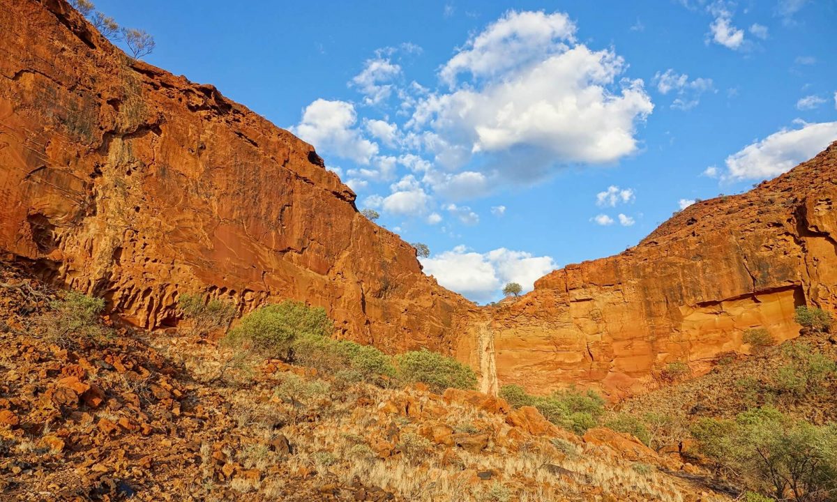
With the sun climbing, it was time to explore. The Escarpment Walking Trail hugs the crumbling cliffline, linking up three tracks that delve into the canyons that cut into the range. These are Temple Gorge, Drapers and Honeycomb. It makes for a full day of exploring, because there’s plenty to see and check out within the gorges, but you can always drive between each one. The interior of the eroded plateau is a maze of deep canyons, open gullies and sheer cliffs; shale and sandstone monuments carved by the movements of ancient seabeds, and millennia of wind and flowing water.
Between rubble slopes and stunning time-weathered boulders, there’s brilliantly honeycombed rock faces and patterns of erosion just about everywhere you look. Nooks, caves and crevices in the red stone provide habitats for a number of species of bats and pythons. The beautifully carved gorges are a platform for seasonal streams and waterfalls.
In fierce opposition to the hot, dry arid landscape, the area is a biological hotspot. There are twisted fig trees in the gorges and the spinifex atop the plateau. Wattles, mallee and spectacular showings of wildflowers are spread across the surrounding Lyons River Valley Plain. With rare rainfall comes particularly vivid bursts of colour. Clumps of woolly purple-pink Mulla Mulla shroud the expanse of red sand.

With such an ancient land comes the expected wealth of history to accompany it. This begins with the native history of the Inggarda people, who knew the ranges as Mundatharrda. It has served as an important spiritual haven and meeting place for surrounding tribes for millennia. Recent generations of their descendants grew up and worked on surrounding stations, continuing to care for and watch over the land even today.
On the European front, it was first explored by Francis Gregory in the 1800s. Within twenty years pastoral land and stations had risen, fast swallowing huge swathes of native land. Thankfully, due to the sheer lack of water throughout the area, heavy grazing never truly occurred. This left the ancient landscape largely intact when the national park was formed in 1993.
Today, the park is a part of the Wool Wagon Pathway. This is a self-drive trail that runs between Geraldton and Exmouth, and one of three Gascoyne Murchison Outback Pathways. On the drive in from Gascoyne Junction, keep an eye out for the remnants of an old cobbled road. It’s the result of a hand-made highway constructed in the 1930s, in an attempt to assist the mail runs to remote properties in the area.

While the eastern side of the Kennedy Range is the most easily accessible, the western edge of the park hides a vast trove of outback secrets. Rougher, wilder and even more isolated, this area is really only suited to well-equipped 4WD tourers. More gradual than the sheer cliffs to the east, the low plateaus, crumbling mesas and rugged buttes here are broken by stony plains, sandy rises and arid grasslands. From the soft sand of the Gascoyne River crossing, the trails across the area are wild and unmarked. These require appropriate planning and navigation.
If you’re heading back towards Carnarvon, or coming from it, Rocky Pool is definitely worth checking out. About 40km from Carnarvon is a signposted dirt track to the north. This leads to a large pool filling a bend in the mostly dry Gascoyne River. Here, you’ll find water almost all year round, making for a serenely beautiful Outback waterhole.
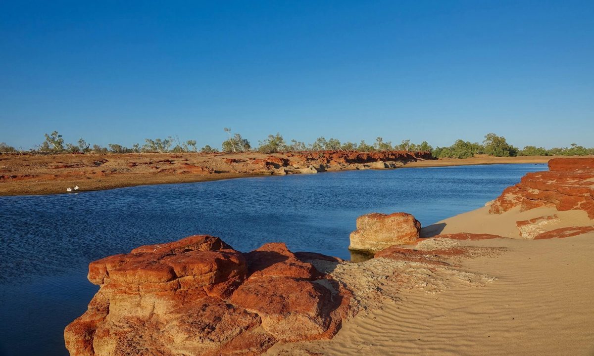
Gnarled platforms of red rocks and wind-rippled sand sit starkly around a long pool of deep blue water. This compliments the vibrant greenery and pale trunks of ghost gums and paperbarks. It’s another wonderfully isolated place, the perfect spot for a cool swim after a couple of hot days in the ranges. Gentle dusk light bathes the rugged surrounds. Come here to be serenaded by the melodic cacophony of hundreds, if not thousands, of ducks, cockatiels, budgerigars, corellas, galahs and other birds coming in to drink.
Looking for your next place to camp? Check out Caravan & Camping WA.
Categories:
Tags:
Key Industry Partners