Barrington Tops National Park near Gloucester on the NSW mid-north coast is a place of striking diversity. If you spend a few days here with some camping gear on your back, you will wander through a constantly changing landscape. Ancient rainforests, rare sub-alpine wetlands, pristine mountain streams and historic huts are waiting to be found. If you brave the elevation in winter, you might even be rewarded with a dusting of snow.
The seasonal closure of the Barrington Trail to 4WDs is an added bonus that just happened to coincide with the easing of NSW’s travel restrictions. Throw in the June long weekend and a nasty bout of cabin fever. What more encouragement could an idling hiker possibly need?
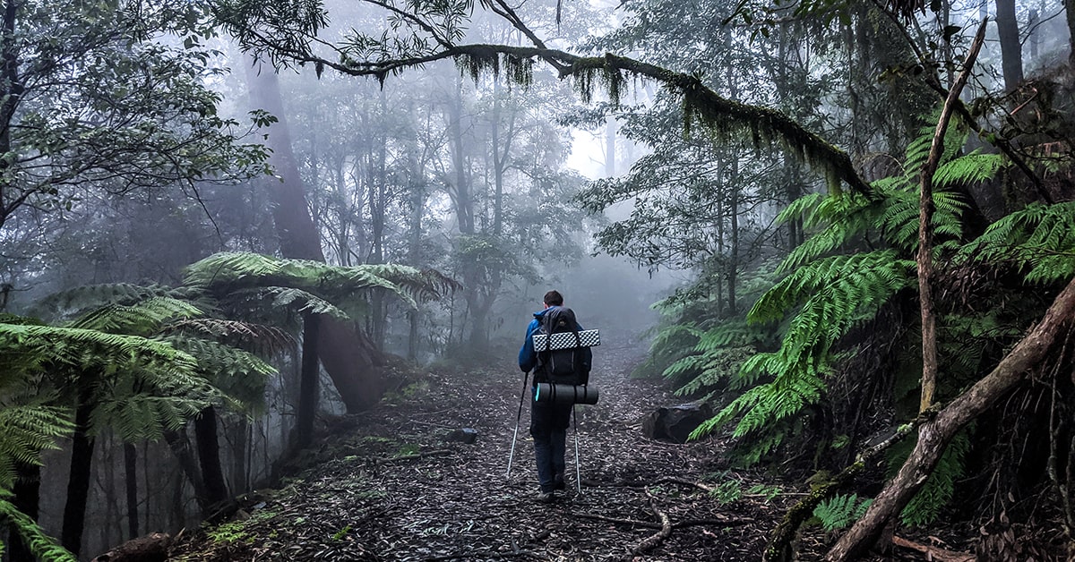
There are tracks leading up onto the Tops from all sides of the park, none as steep as the Corker. But after waiting out 2020’s various apocalypses on the couch, a lactic acid party in the legs seemed like the logical choice. The drive to Lagoon Pinch picnic area takes us up to 600m. From there, the Corker ascends another 900m over 8kms. After that, my partner Sam and I would be looping together a bunch of tracks up around the 1500m mark, with a couple of nights camping in between.
Some might say an uphill slog is a demoralising way to start a hike. But I see some value in getting the lung-torture over and done with, and to be fair, coming down ain’t no picnic either. Regardless, I think anyone can agree there’s something pretty special about setting off through lush mossy rainforest, and finding yourself surrounded by mountain gums and snow grass just 8km later.
For all its steepness, the climb is over surprisingly quickly. About halfway along the track more or less levels out. If you have the time and some bush-whacking prowess, the walkers’ hut hidden to the right near the top would make a fun little diversion. Not to mention a terrific spot to camp, but it does take some dedication to find it.
We’re destined instead for Wombat Creek campground, 300m down the Link Trail. There’s a long-drop near the junction and further towards the creek. We take our pick from a handful of grassy clearings sheltered by dense forest. Fallen old growth decorated with lichen and fungi is strewn around the forest floor. Through the understorey of ferns and fuzzy stones, a pristine creek tinkles.
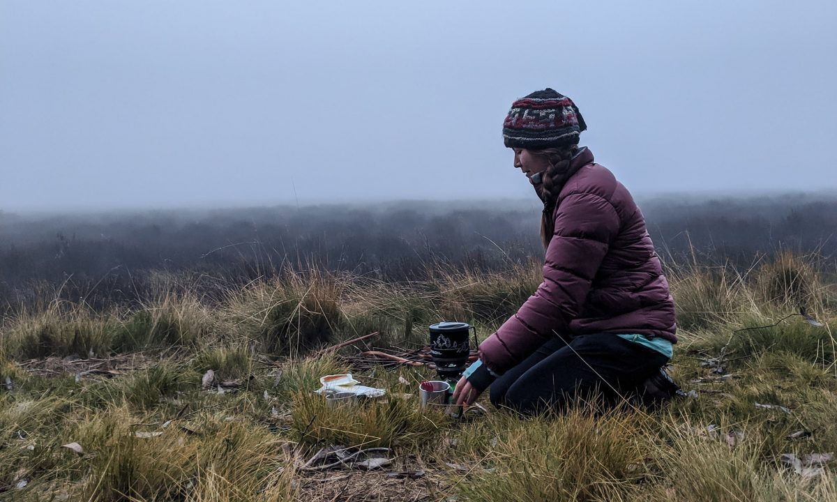
Night arrives quickly in winter, but with the help of a small wheezing fire, we manage to keep blood flowing to our fingers long enough to shovel down a rehydrated dinner and resist the refuge of our sleeping bags for a couple of lazy hours.

Setting off the next morning to shards of ice crunching underfoot comes almost as a surprise. Had it really dropped below freezing overnight? I guess there’s a lot to be said for paranoid sleep systems. Mine involved two sleeping mats (closed cell and inflatable), a -5 down bag, every layer of clothing I’d brought with me, and a whole lot of sweat.
It’s a short detour to Carey’s Hut and Carey’s Peak. The latter is one of the few tracks on our route that isn’t a disused management road or relic of the area’s mustering days. The bush brushing against us as we walk single file makes for a nice change. The lookout here is also one of the few opportunities for views out over the valley.

Sunrise and sunset are primetime at the lookout, and you can do the there-and-back easily enough from Wombat Creek with headlamps. Alternatively you can doss down in the nearby clearing, marked by the old bushwalker’s hut, rusting away yet miraculously still standing after 90 years.
After backtracking and following Careys Peak Trail briefly we veer left onto Edwards Swamp Trail, a scenic 6km shortcut that takes us beside sub-alpine wetlands and squelching around numerous streams that feed into it. The swamp is named after one of the region’s early pastoralists who lived on the plateau over the summer months to graze cattle, though the hut and stables that once stood here were lost to fire in 1946.
At the time of our visit to Barrington Tops the forest along this section showed damage from the more recent summer fires. Recovery was underway, with still-green treeferns dotted around and frothy new growth spiralling around the mountain gums like feather boas.
We’re within cooee of our planned lunch stop when we hit the first real snag. The Barrington River appears to have claimed the track. Normally I’m all for wet feet but winter at 1500m is neither the time nor the place. So rather than gamble on a jump with our 15kg packs, we decided to schlep off-course through the bog in search of some wobbly rocks to stagger across, poles once again proving their worth.
Junction Pools is a beautiful spot. Spring-through-summer it’s accessible to 4WD campers via the Barrington Trail. I’ve read that on weekends they come in droves, but who could blame them? Barrington Creek’s water is the clearest I’ve ever seen and deep enough for a polar-type plunge if that’s your thing. A tumble of boulders create a chain of natural pools and pale yellow snow grass glinting in the sun carpets the banks. Drowsing midday away by the water I can’t help but wish we’d booked our second night here. Ah well, next time.
Turns out Black Swamp is a lovely campsite too. But to get there we first have to walk up Aeroplane Hill. It’s not a huge hill by any stretch. But with the extra 3L of water we’re now carrying to see us through the rest of the trip, I’m feeling the burn in my legs. Still, it’s better to be on the ground than in the air. Many air crafts have met grim fates on the Tops. This particular hill pays tribute to the RAAF Mosquito fighter bomber that came down in poor weather during a training mission in 1945. It serves as a reminder that even at this not-so-lofty-altitude the weather can be merciless. Thankfully Barrington Tops is yet to remind us of it firsthand.
At camp we’re greeted to slender, well-spaced gums, thick, spongey snow grass and a window through the trees offering views over its namesake wetland. It’s a refuge for various threatened species, such as the broad-toothed rat and glandular frog. A throng of bike-packers already had dibs on the main spot so we doubled back to a small, swamp-side clearing and hastily set up.

The day’s last light seeping through a storm cloud in the distance and setting the swamp aglow is a beautiful sight. Disposing of a tiny leech that has latched on to my finger does detract from the serenity somewhat. Later, guilt-stricken in the murky dead of night, I become convinced that the leaf shadows cast across our tent are an army of its bloodthirsty mates coming for revenge.
In the morning the swamp was gone. The most magnificent cloud had crept in through the night and seemingly swallowed the plateau whole.
I’d been hoping for conditions like this. There are few places better suited to a white-out than the drippy, droopy, millenia-old rainforests of Barrington Tops. I couldn’t wait to close our loop and be back on the Corker Track.

The sunkissed Gondwana-green rainforest of two days ago has become a different world, obscured in the sea of milky grey. The towering Antarctic beech trees are like ghosts in the mist. It’s not until we are right upon them that the details of the forest come into focus.
Look up at the canopy’s staghorns and draperies of mosses and vines. It’s a welcome distraction from the shake in my knees and my toes sliding dangerously close to the front of my boots. Not to mention we’re now in a light yet freezing rain that’s making the track especially slick.
Sam’s been using poles for the first time in several years of multi-day hiking. Clearly taken by their effectiveness, he practically skis down the mountain.
I’m not as keen to get back so quickly. Barrington Tops is like nowhere else I’ve ever walked. With uncertainty continuing its reign over both the natural and travel worlds, I’d be foolish not to savour every last moment of this.
To find more great camping itineraries, visit our website!
Categories:
Tags:
Key Industry Partners